Hyderabad’s Ongoing Monsoon and What’s Coming Next
Hyderabad has been soaked to the bone over the past few days as monsoon rains returned with unexpected intensity. After a relatively moderate start to the season, the first week of August brought heavy showers that transformed the city’s landscape into a wet, chaotic puzzle. From sudden cloudbursts to continuous overnight drizzles, the city’s weather has kept residents guessing—and indoors.
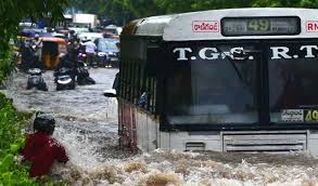
The rain activity has been primarily caused by an active low-pressure system developing over the Bay of Bengal, which moved inland through the eastern coast and settled over central Telangana. This system, combined with favorable monsoon currents and high humidity levels, led to intense precipitation, especially during the nights and early mornings. In just 48 hours, some areas received more than 120mm of rainfall, which is above average for early August.
Neighborhoods like Banjara Hills, Kukatpally, Chandanagar, and Miyapur recorded some of the heaviest downpours, leading to localized waterlogging and slow-moving traffic. Meanwhile, the city’s outskirts and hilly terrains saw a different challenge altogether—overflowing lakes and minor landslides in certain areas, though no major damage has been reported so far.
What’s interesting about this year’s monsoon pattern is its unpredictability. Unlike the steady, predictable rains of previous years, Hyderabad is experiencing sudden bursts followed by long dry spells. Meteorologists attribute this to shifts in wind patterns and irregular behavior of the southwest monsoon, possibly linked to broader climatic shifts affecting much of South Asia.
So, when is the next wave of rain expected? According to the Indian Meteorological Department’s latest models, Hyderabad is likely to see another round of heavy to very heavy rainfall between August 14 and 17. This is due to a new monsoon trough forming over Chhattisgarh and moving southwestward toward Telangana. Residents should expect intense rain spells, especially during late evenings and nights, with the possibility of thunderstorms and gusty winds.
Light to moderate rainfall is also expected to continue intermittently throughout the third week of August. While daytime temperatures will remain in the 27–30°C range, high humidity will make the atmosphere feel warmer and heavier than usual. Those planning travel or outdoor events during this time should monitor updates from IMD or local weather alerts for safety.
Looking further ahead, meteorological models suggest that rainfall may taper off slightly in the last week of August before another potential surge in early September. Though it’s still too early to forecast with certainty, Hyderabad might experience an extended monsoon season this year, with above-average rainfall overall—good news for groundwater levels, but something to prepare for if you're not a fan of wet mornings and delayed commutes.
For now, residents are advised to stay updated, avoid flood-prone routes, and enjoy the brief quiet spells between showers. Whether you're sipping chai by the window or navigating puddle-filled lanes, one thing is clear—monsoon in Hyderabad is far from over.